
Most of the houses on the Abingdon Road were built by the end of the 19th century, but this one, at 40 Abingdon Road (on the corner of Whitehouse Road), was a little later.
The suburbs of Grandpont and New Hinksey were given a boost in 1908 by the opening of Hinksey Halt, a small railway stop reached by a path from the northern end of Wytham Street. Housing development south of New Hinksey, on Norreys Avenue and Sunningwell Road, was almost complete by 1914. In June 1914, at a time of deep recession in the building trade, the City Council approved a plan by R Bartlett to lay out the field south of Sunningwell Road in 204 building plots, with roads coming off an extension to Wytham Street and named alphabetically after the county towns of Lincoln, Monmouth, Northampton and Oswestry. The outbreak of World War I postponed any progress on Bartlett's estate, and in 1917 the area was being used as allotments, but housing (much of it built by the firm TH Kingerlee & Sons) spread rapidly in the 1920s, helped by the development of motor bus services from the centre of Oxford out to the suburbs. Originally there was to be a crescent of houses - Chatham Crescent - coming off the western side of Wytham Street, on the section between Lincoln and Monmouth Roads, but this was never built. As a result the houses which are now on this part of Wytham Street have extremely long gardens, going all the way down to the railway line.
There was further housing built at the southern end of the Abingdon Road, in the area known as Cold Harbour (or Arbour), in the 1920s. In 1923-25 the City Council built 110 council houses north of Weirs Lane on land bought from University College. A further 76 houses were built to the south, in 1925-27, on land bought from Morrell's Trustees (who owned the brewery in St Thomas's). These were to re-house residents who had been displaced by the demolition of English Row - one of the many narrow courtyards off St Aldates - as part of a slum clearance programme. It was the Provost of Oriel, who sat on the City Council, who suggested naming the newly-made local streets after British statesmen: Pitt (later changed to Chatham), Fox, Canning and Peel.
There were a few 19th-century cottages on Weirs Lane already, some with paper roofs. The lane led originally to the Weirs paper mill and to a footbridge over the weirs on a loop of the river which rejoins the main Thames further south at Kennington. From 1897 there was a free punt ferry to take people across the river to Iffley. Much earlier there had been a ford crossing Weirs mill stream, lining up with the Roman road which came down Boars Hill and past where Red Bridge is now, on its way towards Alcester (see M Henig & P Booth, Roman Oxfordshire (Sutton, 2000)). In 1937 a high-arched concrete footbridge was built which, in 1962, was replaced by Donnington Bridge. This was the first road bridge to be constructed over the Thames in five centuries, and it allowed motor traffic to cross the river here for the first time. Hence Weirs Lane ceased to be a cul-de-sac.
This extract from the 1938 Ordnance Survey map shows housing development south of New Hinksey and in Cold Harbour. None of these terraced houses existed when the previous Ordnance Survey map was drawn in 1921. Notice the bowling green and club house at the western end of Sunningwell Road, which were laid out by the South Oxford Bowls Club in 1933, on land rented from the City Council. The City's Infectious Diseases Hospital can be seen in the bottom right-hand corner.
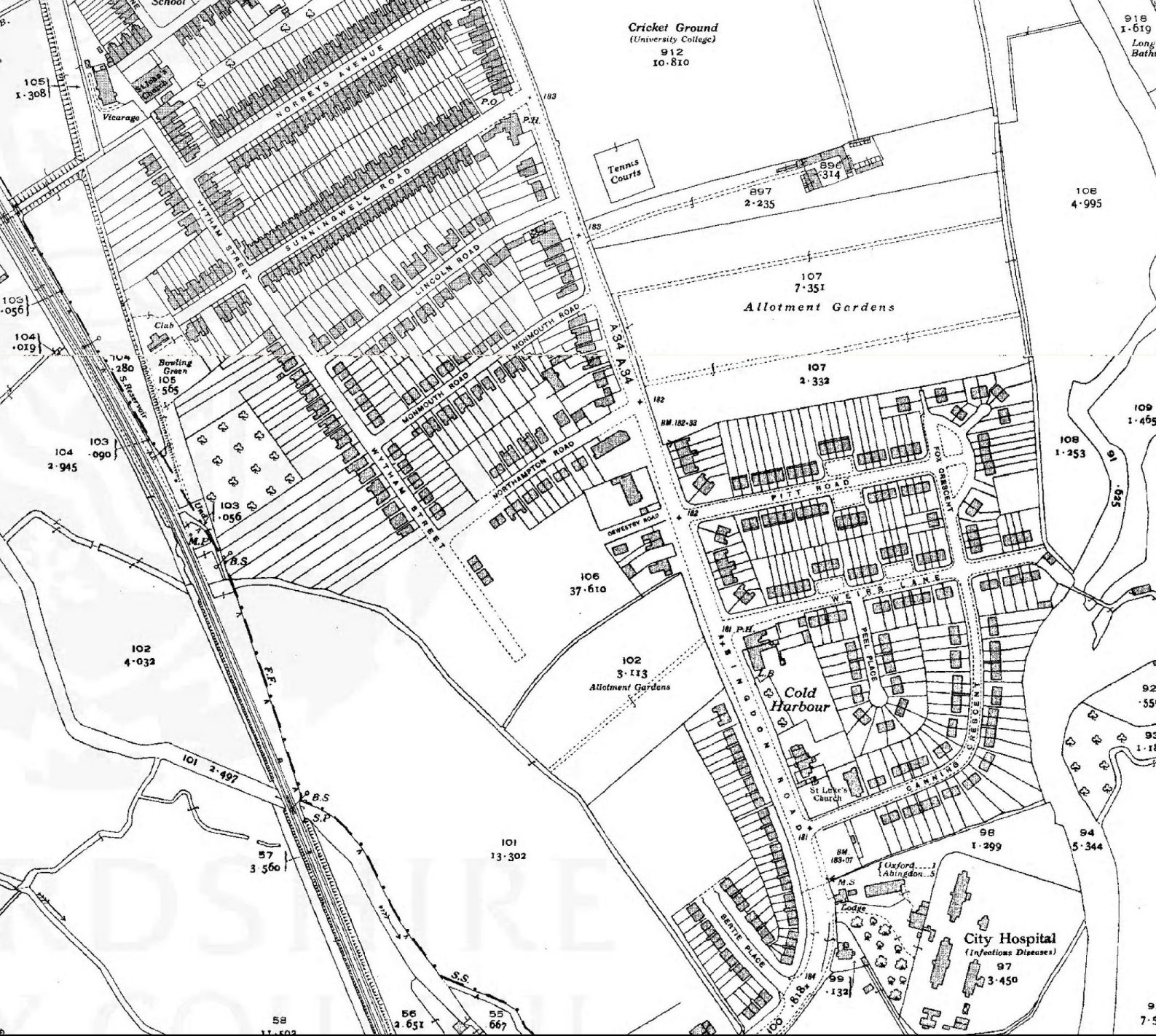
Extract from the 1938 Ordnance Survey map, showing development south of New Hinksey and in Cold Harbour.
The Cold Harbour area was served by St Luke's church, which opened on Canning Crescent in 1933 as a mission hall under the patronage of St Matthew’s church on Marlborough Road. In 1933-6 further council housing was built at the southern end of the Abingdon Road, where it curves south-westwards, on land bought from the Revd JWC Moore. The Council had purchased the site in 1925, with the original intention of building oak-framed houses for tuberculosis sufferers (the Infectious Diseases Hospital being nearby). Instead the Glebe Estate was built for council tenants. The estate, part of which is Bertie Place, was initially built by a Coventry firm, J Aston & Co, but was completed by Collett & Rogers of Wootton (near Abingdon). In 1938 the South Oxford Baptist church opened on Wytham Street (though after the map above was drawn). In 1997 it was discovered that land around Bertie Place was contaminated and major work was carried out to remove and replace the top soil.

These houses at the southern end of Wytham Street, on the corner of Oswestry Road, do not appear on the 1938 map above and must therefore have been built after that date.
Most of the land on the western side of the Abingdon Road (apart from Hinksey Park) was built up by the eve of World War II. Meanwhile the eastern side of Abingdon Road has remained largely as farmland, allotments and college playing fields, mainly due to the ongoing problem of flooding.
- Read more about the development of council estates in South Oxford in Malcolm Graham, Wholesome Dwellings: Housing Need in Oxford and the Municipal Response, 1830-1939 (Archeo Press, 2020).
- Find out more about Grandpont, South Oxford and Cold Harbour in the early 20th century in Carole Newbigging, The Changing Faces of South Oxford and South Hinksey, Books 1, 2 and 3 (Robert Boyd Publications, 1998-2003). These books contain lots of good photographs of local people and places.
- Find out the meaning of street names in South Oxford.
- Read about housing development in South Oxford during the Victorian period.
- Read more about historic flooding in Oxford on Stephanie Jenkins's Oxford History website.
Weirs paper mill shown (left) on an extract from the 1900 Ordnance Survey map and (right) in a painting of unknown date. Painting copyright John Burbank, and reproduced with his permission. There is another painting of the mill here. (Click on either image to close)
![[Cold Harbour OS 1900 Weirs mill highlighted]](/images/photos/Local_history_section/Paper_houses/Cold_Harbour_OS_1900_Weirs_mill_highlighted.jpg "Cold Harbour OS 1900 Weirs mill highlighted")
![[Towles paper mill Cold Harbour Weirs Mill Stream]](/images/photos/Local_history_section/Paper_houses/Towles_paper_mill_Cold_Harbour_Weirs_Mill_Stream.JPG "Towles paper mill Cold Harbour Weirs Mill Stream")
The free ferry footbridge over the Thames at the end of Weirs Lane in 1961, just as work was starting on the Donnington road bridge. Image from Carole Newbigging, The Changing Faces of South Oxford and South Hinksey, Book 3 (Robert Boyd Publications, 2003). (Click image to close)
![[Donnington free ferry footbridge 1961]](/images/photos/Local_history_section/Donnington_Bridge/Donnington_free_ferry_footbridge_1961.jpg "Donnington free ferry footbridge 1961")
Looking north along the the Abingdon Road during floods in 1905. Photograph by Henry Taunt, image © Oxfordshire County Council, Oxfordshire History Centre, ref: HT6798. (Click image to close)
![[Abingdon Road flooded 1905 Taunt]](/images/photos/Local_history_section/Abingdon_Road/Abingdon_Road_flooded_1905_Taunt.jpg "Abingdon Road flooded 1905 Taunt")
On 17 February 1926 the Oxford Journal Illustrated reported the replacement of the 'unstable' wooden bridge with a new iron one, 'a development much appreciated by users of the footpath from the Abingdon Road to the Free Ferry'. (Click image to close)
![[Footbridge from Abingdon Rd to Free Ferry rebuilt OJI 2017-02-1926]](/images/photos/Local_history_section/Suburban_development/Footbridge%20from%20Abingdon%20Rd%20to%20Free%20Ferry%20rebuilt%20OJI%2017-02-1926.JPG "Footbridge from Abingdon Rd to Free Ferry rebuilt OJI 2017-02-1926")
Proposed layout of the Abingdon Road Estate in 1910, showing Chatham Crescent, which was never built. Image © Oxford City Council, Town Hall archives, estate plans ref: 8508. (Click image to close)
![[Abingdon Road Estate]](/images/photos/Local_history_section/Suburban_development/Abingdon_Road_Estate_JR_Wilkins_TH_archive_8508.JPG "Abingdon Road Estate")