The first proposal for a branch line to Oxford, 1837
Isambard Kingdom Brunel's Great Western Railway (GWR) was created by Act of Parliament in 1835 and work started soon after from both London and Bristol. By 1838 the line had reached Steventon, just west of Didcot; travellers from Oxford had now to travel only ten miles by coach to the new railway where they could then catch a train to London. The line proved immediately popular: 77,500 passengers and 12,600 tons of freight were transported from Steventon in 1842, a considerable proportion originating in the Oxford area.
The original prospectus for the GWR included provision for a branch line connecting Oxford with the main London to Bristol line at Didcot. Brunel probably viewed this branch line as a broad gauge gateway into the Midlands. A Bill proposing the line was presented to Parliament in 1837, but in fact this was to be the first of three Bills before the line was finally granted permission six years later.
![[GWR network, proposed route]](/images/photos/Local_history_section/Railway/GWR_network_MacDermot_vol_1_2.JPG "Map showing the proposed GWR route from London to Bristol")
A map from the GWR prospectus showing the proposed route of the railway from London to Bristol. A dotted line going north between the words 'WESTERN' and 'RAILWAY' shows the proposed branch line from Didcot to Oxford. From ET MacDermot, A History of the GWR, Volume 1, 1964 (revised by CR Clinker, 1982).
The first Bill in 1837 proposed that the railway should run into the city approximately parallel with the Cowley Road, terminating in a field adjacent to Magdalen Bridge, near where the junction between Cowley Road and Marston Street is now. (At this time the whole area now known as 'East Oxford' comprised unpopulated open fields.) The track was to be a straight line and virtually level all the way. The terminus station would be 18 feet below ground level and from there the track would run in a cutting to Boundary Brook. Iffley Road would be raised by two feet and be carried over the railway line on a bridge. There would be an embankment as far as Meadow Lane, which would be raised five feet so as to be on a level. From there a major cutting would take the line nearly all the way to Rose Island, opposite Kennington.
![[Proposed GWR line thru Iffley]](/images/photos/Local_history_section/Railway/GWR_Radley-Oxford_land_owner_map_1837_house_details_for_Iffley_Parl_Archives_HL-PO-PB-3-plan215_cropped.JPG "Proposed GWR line thru Iffley")
The proposed route of the GWR line through Iffley Village, 1837 (south-east at the top). Image © Parliamentary Archives, ref: HL-PO-PB-3-plan215.
The proposed route meant the line going right through the ancient village of Iffley. Not surprisingly, villagers objected on the grounds that the necessary large cutting would badly affect wells and would cut people off from their fields.
Christ Church, owners of much of the land to the north of Iffley, also objected, as did major landowners Captain Pechel and Sir George Bowyer of Radley. The City Corporation objected, fearing that the railway would take away road traffic and reduce income from tolls on the Abingdon Road. The Canal Company was understandably opposed to the whole line out of concern for its business interests.
The second proposal, 1838
As a result, the Bill was defeated, but a second Bill followed swiftly in 1838. This time the university objected, fearing for the morals of its students. In particular, there were concerns about providing undergraduates with easy access to London where they might be involved in 'improper marriages and other illegitimate connexions'. The Chancellor of the university, the Duke of Wellington, had at first opposed all railways because they might encourage the lower orders to 'move about', and others were worried about an influx of people into Oxford, visiting the colleges as tourists and 'loungers'. Christ Church and other land owners still objected to the proposed route into the city, and this second Bill was defeated in the Lords.
The third proposal, 1842

Thomas Moule's map of c. 1844, showing the Great Western Railway coming into Oxford (from Didcot), running parallel and to the west of the Abingdon Road, and terminating at Grandpont, just south of Folly Bridge.
A third Bill, in 1842, envisaged the line entering Oxford along a new route, to the west of the Abingdon Road, and terminating at a station in Grandpont, just south of Folly Bridge and outside the city boundary. The Corporation still objected, partly due to concerns about flooding but also because it thought the railway unnecessary and unwanted, arguing that none of the subscribers (i.e. people who had bought shares in the proposed line) were Oxford residents. But in fact opposition to the railway had weakened, the assent of the landowners along the proposed route was obtained and, crucially, the university withdrew its objections, probably because it knew that by now large numbers of students were already boarding the railway at Steventon, ten miles to the south, where it had no jurisdiction. With a station at Oxford, and the inevitable end of the coach service to Steventon, the university could exercise some control over students' travel plans. Moreover, the Bill stipulated that university officials could patrol the new station at Oxford and prevent students from travelling to unsuitable places like Ascot and Henley, and that the railway company could sell undergraduates tickets only to approved destinations.
So this third Bill was finally passed in 1843. Work began on the line, just under ten miles long, in October, and a mild winter allowed it to be completed and opened to traffic on 12 June 1844. A station at Didcot was also built to serve the line. A few days prior to the public opening of the railway a special train carried a party of notables, including Brunel himself, from London. The group arrived in Oxford at the station in Grandpont at around 2pm and were taken over Folly Bridge by stagecoach to the Angel Inn on the High Street for a celebratory meal.
The opening of the new railway line, June 1844
The line ran into Oxford through the area now occupied by Hinksey Park, along what is now the route of Marlborough Road, and terminated just south of the river. The opening of the line to the public on 14 June caused enormous excitement: great crowds gathered in areas adjacent to the railway. In Hinksey Field and South Hinksey a special gala day took place with marquees, tents and exhibitions; parties and celebrations went on late into the evening. Thousands of people watched enthralled as the first public train arrived:
'...one of those rampageous, dragonnading fire-devils ... arrived at a sufficiently astonishing rate, and though gasping for breath and shining with heat, seemed to have turned not one hair more than was deemed proper by each spectator, even after its long and whirlwind chase.' (Jackson's Oxford Journal, 15 June 1844)
Oxford's first railway station, in Grandpont, 1844
The Grandpont terminus of the new line was built on what is now the corner of Marlborough and Western Roads.
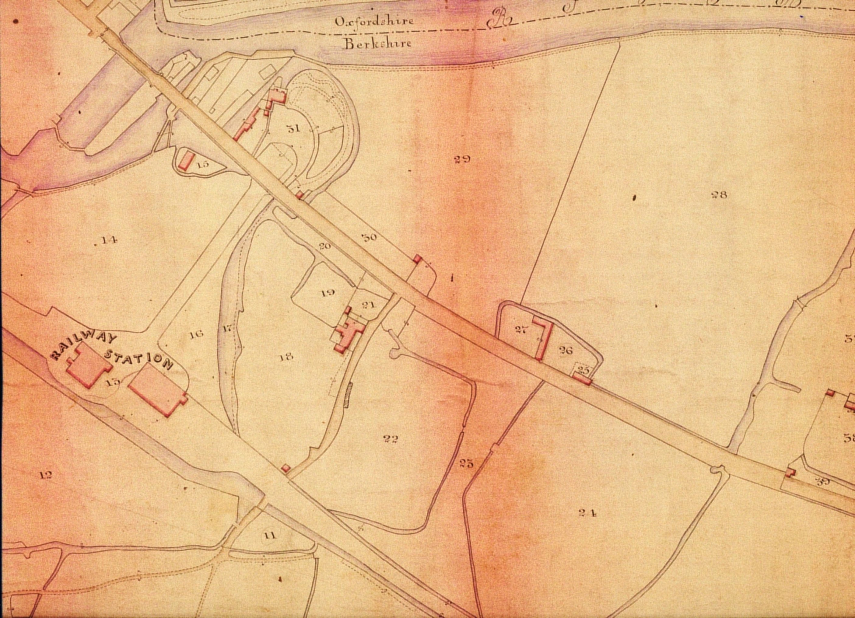
The GWR's Grandpont station shown on a tithe map of 1847. North-east is at the top of the image; the Abingdon Road runs diagonally across the page and crosses the Thames via Folly Bridge near the top left-hand corner. The two buildings of the railway station – the passenger station and, to the north of it, the goods shed – can be seen. The station approach road – now Western Road – leads to the Abingdon Road near Folly Bridge. The building immediately to the south of the number '21' is the old White House pub, on White House Lane (now White House Road). Image courtesy of The National Archives, ref: IR/30/27/3.
The station was a mainly wooden structure with two tracks and small wagon turntables at the terminus ends. A further three tracks ran alongside serving a large goods shed to the north-west of the passenger station. A single track continued 400 yards to the river bank where there was a small loading jetty and a crane. Water for the engines was obtained straight from the Thames and stored within the station area in large barrels, which were manhandled onto the locomotives to fill the tanks.
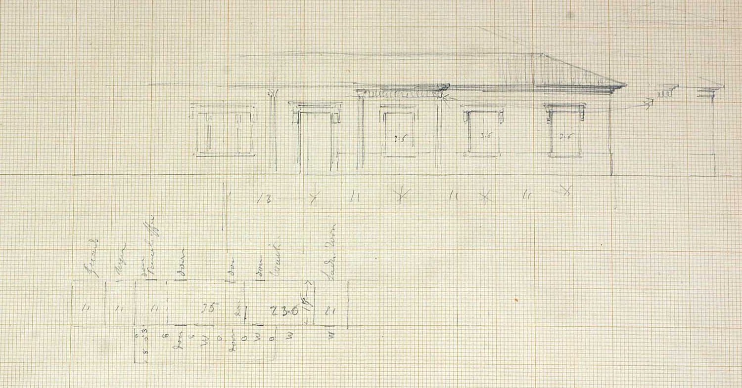
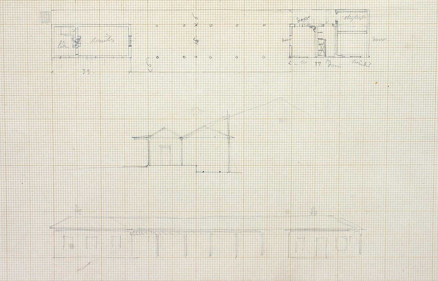
Isambard Kingdom Brunel's sketches of the proposed station at Grandpont. Images © Bristol DM162 Brunel Collection, Section 8 - sketchbooks, 1-IKB, 3 - GWR sketchbooks, vol 18, folios 33 & 34.

A plan of part of the proposed alterations in 1852, to change the station from a passenger station to a goods station. Image from Network Rail, courtesy of Laurence Waters, Great Western Trust Archives, Didcot.
![[The GWR station at Grandpont in 1852]](/images/photos/Local_history_section/Railway/22_Grandpont_railway_station.JPG "The GWR station at Grandpont in 1852")
Looking at the side of the GWR's Grandpont station in 1852. Passengers entered the station through the building on the right-hand side, the façade of which is shown in Brunel's sketches and the plan above. Image © Oxfordshire County Council, Oxfordshire History Centre, ref: D269243a.

Stephen Quelch recalling one of the first railway excursions to London in 1844. From S Quelch, Early Recollections of Oxford, in Twelve Letters Addressed to the Editor of the Oxford Chronicle, by an Old Freeman, 1900.
Passengers were permitted to carry luggage of up to 40 pounds in weight or 6 cubic feet in dimension for free, and maximum fares for people and animals were set by the Act of Parliament.
The arrival of the railway had a positive effect on local property prices; as early as July 1844 wharves adjacent to Folly Bridge were being advertised as 'very near to the Oxford station of the branch railway from Didcot to Oxford, and in a situation most desirable for trade'
Trouble with a paper house
Where the railway line intersected the Abingdon Road, just north of Kennington, there was to be a bridge taking the road over the railway. However, the building of this bridge was delayed by a man called John Towle, who, believe it or not, erected a paper house on the line of the proposed railway embankment, perhaps to get compensation or perhaps just to make life difficult for the railway company.
- Read more about John Towle and his extraordinary house.
In fact Towle's paper house did not delay the opening of the railway. The railway inspector directed that the former course of the Abingdon Road, crossing the railway at a level crossing, should be kept until the bridge (later known as Red Bridge) and its approaches had been built properly, and the railway opened on time.
- See what may be a picture of the level crossing taking the railway over the Abingdon Road on the website of the Old Ticket Office at Culham Station.
Hence Oxford's first railway line, a Great Western broad gauge, was in place in June 1844, a major addition to the landscape south of the city. A new toll gate and toll house were built on Folly Bridge to intercept traffic from the new railway station. The toll house on Folly Bridge survives. The coming of the railway also prompted the development of a new suburb half a mile out of the city - New Hinksey.
The opening of the Didcot to Oxford branch of the Great Western Railway not only provided ease of movement for people and goods, it also facilitated the spread of an invader - the Oxford Ragwort.
- Read about the Oxford Ragwort on the website of the Old Ticket Office at Culham Station.
The extension of the GWR line north and the building of a new station on the Botley Road, 1852
In 1850 the GWR line was extended north from Millstream Junction (half a mile south of the Grandpont terminus station) to Banbury, and in 1852 to Birmingham. This was a mixed gauge line. Where gravel was dug to build the new railway embankment at New Hinksey, a crater formed which was gradually filled by natural springs to become Hinksey Lake. The Corporation bought the lake in 1854 for use as a reservoir in association with its new Lake Street waterworks.
With the opening of a new line to Birmingham in 1852 the GWR had at last gained a foothold in the Midlands. But the extended layout meant that trains arriving in Oxford from the south had to deposit passengers for Oxford at the Grandpont station, and then reverse half a mile to Millstream Junction before continuing on northwards. Conversely, trains arriving from the north had stop at Millstream junction and reverse up to the station at Grandpont to deposit passengers for Oxford, before continuing on south. The Grandpont station therefore became highly inconvenient, and so in 1852 the GWR built a new station at the eastern end of the Botley Road, adjacent to the LNWR station which had been built a year earlier. The GWR station was on the site of Oxford's present railway station, and the LNWR one was where the Saïd Business School is now.

Henry Taunt's map of the Thames in Oxford, 1879, showing the layout of the railway when all three stations were still in place. Image from A New Map of the River Thames (3rd ed), Taunt & Co, 1879.
The closure of the Grandpont station, 1872
With the building of the new GWR station at the eastern end of the Botley Road, the Grandpont station was closed to passengers, though it continued in use as a goods station until 1872, when broad gauge was finally abandoned in Oxford. The station buildings were dismantled, the track taken up and the land sold off for housing development. It was ideal for this purpose, as the embankment, station site and approach road had already been raised above flood level. The Grandpont housing estate was laid out in the early 1880s by the Oxford Building & Investment Company. Marlborough Road follows the course of the old railway line, and houses there have a higher floor level at the front than at the back, as they rest against the side of the former railway embankment. What had been the station approach road was built upon and named 'Western Road' after the Great Western Railway.
Hence Grandpont lost its railway station, but another small station, Hinksey Halt, was opened near the southern end of Hinksey Lake in 1908.
Hinksey goods yards and Hinksey sidings, 1942
Oxford's location in central southern England meant that it became an increasingly busy railway intersection, particularly for goods being carried north-south and east-west across the country. The goods yards at the Great Western station on the Botley Road were dead-ends and so not suitable for exchanging goods between through trains. So to increase capacity, new exchange or marshalling yards were opened at Hinksey in the summer of 1942. These were north and south of the footbridge which carries the Devil's Backbone over the railway tracks, and adjacent to the former site of Hinksey Halt. The yards were constructed with the help of Italian Prisoners of War from No. 43 Harcourt Hill Working Camp, near North Hinksey.
Goods trains called into the Hinksey yards (or sidings) on their way through Oxford to drop off wagons, which were sorted according to destination before being picked up by another train. There were up [to London – south] and down [north] yards, with twenty parallel tracks and capacity for 1,000 wagons. Hinksey yards became very busy and were soon in use 24 hours a day.
Michael Hand, who grew up on Wytham Street, recalled '…open wooden-sided wagons - black, red or brown with bold white lettering proclaiming the names of their owners. By day and night the trucks were shoved noisily about by fussy little tank engines, rather as sheep are nudged hither and thither by sheep dogs. From the vantage point of the bridge the skilful art of the shunter could be seen as he ran beside moving wagons deftly wielding the pole with which he uncoupled them. At midnight on New Year’s Eve engine men on duty at the yard would sound a fanfare on the whistles of their locomotives to mark the arrival of the new year.' (From Carole Newbigging, The Changing Faces of South Oxford and South Hinksey, Book 1, p.45 (Robert Boyd Publications, 1998).)
During the preparations for D-Day in April 1944, over 1,200 trains passed through Hinksey yards. They continued in use after the War, until the late 1960s. The extent of the yards in 1958 can be seen on this Ordnance Survey map.

Plan showing the development and demise of the Hinksey Yards, 1943-1974. Image and information about the yards courtesy of Laurence Waters.

(Left) Looking south across the up (south) yard at Hinksey Sidings, 1950s. The white single-storey building on the right of the picture was erected when the yard was opened. The yard was shunted 24 hours a day and there were ten to twelve goods guards as well as other railway workers based at Hinksey (rather than at Oxford station). This building was used as a signing-on point, with offices, a rest area, eating facilities (though not a canteen) and WCs. (Image belonging to Sidney's daughter Brenda Horwood, courtesy of Gill Garrett / Debby Forbes.)
![[GWR shunters, up yard, Hinksey Sidings, 1950s]](/images/Sidney%20Horwood%20left%20and%20Len%20GWR%20shunters%20Hinksey%20Sidings%201950s%203%20Brenda%20Horwood.jpg "GWR shunters, Hinksey Sidings up yard, 1950s")
(Left) Sidney Horwood and his mate Len with a saddletank engine in the up (south) yard at Hinksey Sidings, 1950s. Sidney Horwood (1891-1962) worked as a GWR shunter for almost all of his adult life, seemingly much of it at Hinksey Sidings. He and his family lived nearby at 262 Marlborough Road. The footbridge over the tracks, and far behind it, one of the gas holders at the St Ebbe's gas works, can be seen on the far left of the picture. (Image belonging to Sidney's daughter Brenda Horwood, courtesy of Gill Garrett / Debby Forbes.)
![[GWR shunters with poles Hinksey Sidings, 1950s]](/images/Sidney%20Horwood%20right%20and%20Reg%20GWR%20shunters%20Hinksey%20Sidings%201950s%201%20Brenda%20Horwood.jpg "GWR shunters with poles Hinksey Sidings, 1950s")
(Left) Sidney Horwood (on the right) and his mate Reg at Hinksey Sidings, 1950s. They are holding the long shunting poles which they used to uncouple the wagons. (Image belonging to Sidney's daughter Brenda Horwood, courtesy of Gill Garrett / Debby Forbes.)
South Oxford nearly gets a new station, 1985
The Hinksey goods yards closed in the late 1960s, as the volume of rail freight had declined, and many of the tracks were removed. In 1985 a proposal was put forward to construct a new station - Hinksey Parkway - on the site of the old up yard. The station, with a large car park and its own bus and car connections to the ring road via Redbridge, would have helped alleviate congestion at the main station. However, there were strong objections from local residents and councillors, and the idea was abandoned. A prefabricated station structure had already been built in anticipation, but it was taken to Devon instead, and used at Tiverton Parkway.
In 1998 Railtrack established a 'virtual quarry' at Hinksey, which caused considerable annoyance locally. Today Hinksey is used as an engineering yard, operated by Colas Rail, and the BMW trains carrying newly-built Minis from the car factory at Cowley still stop here on their way to Purfleet and the Channel Tunnel.
To find out more about the railway in Oxford see:
- The South Oxford railway history trail created in June 2019 for the 175th anniversary of the opening of the Didcot to Oxford Great Western Railway branch line.
- Laurence Waters, Railways of Oxford: A Transport Hub that Links Britain (Pen & Sword, 2020).
- Robert Sephton, 'How the Railway came to Oxford', parts 1, 2 & 3, Oxfordshire Local History, vol 6, nos 2, 3 & 4 (OLHA, 1999-2000).
- Liz Woolley, 'How the Railway Changed Oxford', Oxfordshire Local History, vol 9, no 4 (OLHA, 2014).
- John Leigh, Iffley, Brunel & the Great Western Railway (Iffley Local History Society, 1997).
- Laurence Waters, Rail Centres: Oxford (Ian Allen, 1996).
- Laurence Waters & Tony Doyle, British Railways Past and Present: No 15, Oxfordshire (Past & Present Publishing, 1994).
- Laurence Waters, Oxfordshire Railways in Old Photographs (Sutton, 1989).
- Adrian Vaughan, The Heart of the Great Western (Silver Link, 1994).
- Rob Kinchin Smith, 'Oxford, Former LMS Station', South Midlands Archaeology, no 29 (1999).
- Julian Munby, Andy Simmonds, Ric Tyler & David Wilkinson, 'From Studium to Station: Rewley Abbey and Rewley Road Station, Oxford', Oxford Archaeology Occasional Paper, no 16 (2007).
- 'Oxford, Rewley Road LMS Swing Bridge', South Midlands Archaeology, no 25 (1995).
- Oxford Preservation Trust, Rewley Road Swing Bridge Restoration Project.
- Liz Woolley, 'Osney: a Railway Enclave?' Oxfordshire Local History, vol 8, no 3 (OLHA, 2008).
- Jack Simmons, 'The Proposed GWR Railway Works at Oxford in 1865' in Jack Simmons, Railway in Town and Country, 1830-1914 (David & Charles, c.1986).
- Liz Woolley, Oxford's Working Past: Walking Tours of Victorian & Edwardian Industrial Buildings (Huxley Scientific Press, 2012).
The route proposed in 1837 for the Great Western Railway coming in to East Oxford, terminating just south-east of Magdalen Bridge. The road labelled 'to Cowley' is the Cowley Road and the road labelled 'to London' is the Iffley Road. Image courtesy of the Parliamentary Archives, ref: HL/PO/PB/3/plan 215. (Click image to close)
![[GWR_Radley-Oxford_plan_1837_Parl_Archives_HL-PO-PB-3-plan215]](/images/photos/Local_history_section/Railway/GWR_Radley-Oxford_plan_1837_Parl_Archives_HL-PO-PB-3-plan215.JPG "Railway/GWR_Radley-Oxford_plan_1837_Parl_Archives_HL-PO-PB-3-plan215")
The Great Western Railway route proposed in 1842, and accepted. The line came in to Oxford from the south, ran parallel and just to the west of the Abingdon Road, and terminated south-west of Folly Bridge (at the far left-hand side of the image). The map is on its side, so east is at the top. Image courtesy of the Parliamentary Archives, ref: HL/PO/PB/3/plan 1843/01. (Click image to close)
![[GWR, Kennington-Oxford, 1843, plan, Parl Archives HL-PO-PB-3-plan1843-01]](/images/photos/Local_history_section/Railway/GWR_Kennington-Oxford_1843_plan_Parl_Archives_HL-PO-PB-3-plan1843-01.JPG "GWR, Kennington-Oxford, 1843, plan, Parl Archives HL-PO-PB-3-plan1843-01")
Extract from An Act for Making a Railway from the Great Western Railway to the City of Oxford, 11 April 1843. (Click on either image to close)
![[GWR Oxford Act of Parliament 1843 (6) university control 1]](/images/photos/Local_history_section/Railway/GWR_Oxford_Act_of_Parliament_1843_6_university_control_1.JPG "GWR Oxford Act of Parliament 1843 (6) university control 1")
![[GWR Oxford Act of Parliament 1843 (7) university control 2]](/images/photos/Local_history_section/Railway/GWR_Oxford_Act_of_Parliament_1843_7_university_control_2.JPG "GWR Oxford Act of Parliament 1843 (7) university control 2")
Image from the Bodleian Library, ref: Bodl GA fol B 71, 132. (Click image to close)
![[Auction of wharfs Folly Bridge 1844 Bodl GA fol B 71 132 description]](/images/photos/Local_history_section/Folly_Bridge/Auction_of_wharfs_Folly_Bridge_1844_Bodl_GA_fol_B_71_132_description.JPG "Auction of wharfs Folly Bridge 1844 Bodl GA fol B 71 132 description")
Map accompanying Daniel Trinder's Award 1844, showing the proposed line of the Great Western Railway as it approached Oxford and the owners of the land through which the line would pass. Henry Greenaway's two fields between the Abingdon Road and the railway line were to become the site of the suburb of New Hinksey. Image © The Oxfordshire History Centre. (Click on image to close)
![[Map accompanying Daniel Trinders Award 1844]](/images/photos/Local_history_section/Railway/Map accompanying Daniel Trinders Award 1844 line of proposed GWR railway.jpg "Map accompanying Daniel Trinders Award 1844")
The up platform at Oxford's Great Western Railway station, c. 1902. Image courtesy of Laurence Waters. (Click on image to close)
![[GWR Oxford station up platform c. 1902 Laurence waters Nov 2020]](/images/photos/Local_history_section/Railway/GWR_Oxford_station_up_platform_c._1902_Laurence_waters_Nov_2020.jpg "GWR Oxford station up platform c. 1902 Laurence waters Nov 2020")