Pubs and alehouses were ubiquitous in towns and cities and traditionally they were places not only to drink but also for men to meet and discuss (some even contained working men's libraries), to watch penny gaff plays, to gamble and to bet on boxing, ratting, dog- and cock-fighting. Throughout the 19th century there was growing concern over the amount of time and money that the urban working classes were spending in pubs. In 1868 it was claimed that more money was being spent on drink than on food in Oxford. The rising Temperance and Band of Hope movements attempted to lure men away from pubs, which were considered by many to be a major cause of most social ills: poverty, crime, promiscuity and public disorder. Temperance workers regularly attended the magistrates' courts in order to object to licensing applications. However, despite these efforts, there was, if anything, an increase in beer consumption, particularly from the 1870s onwards, as real wages rose. In Oxford in 1883 there were at least 319 establishments from which alcohol could be bought - this was when the population was around 32,000, so almost one for every 100 men, women and children. As Oxford's suburbs expanded, even more pubs were built to serve the growing population.
There used to be at least fourteen pubs in South Oxford, but now there are only four left:
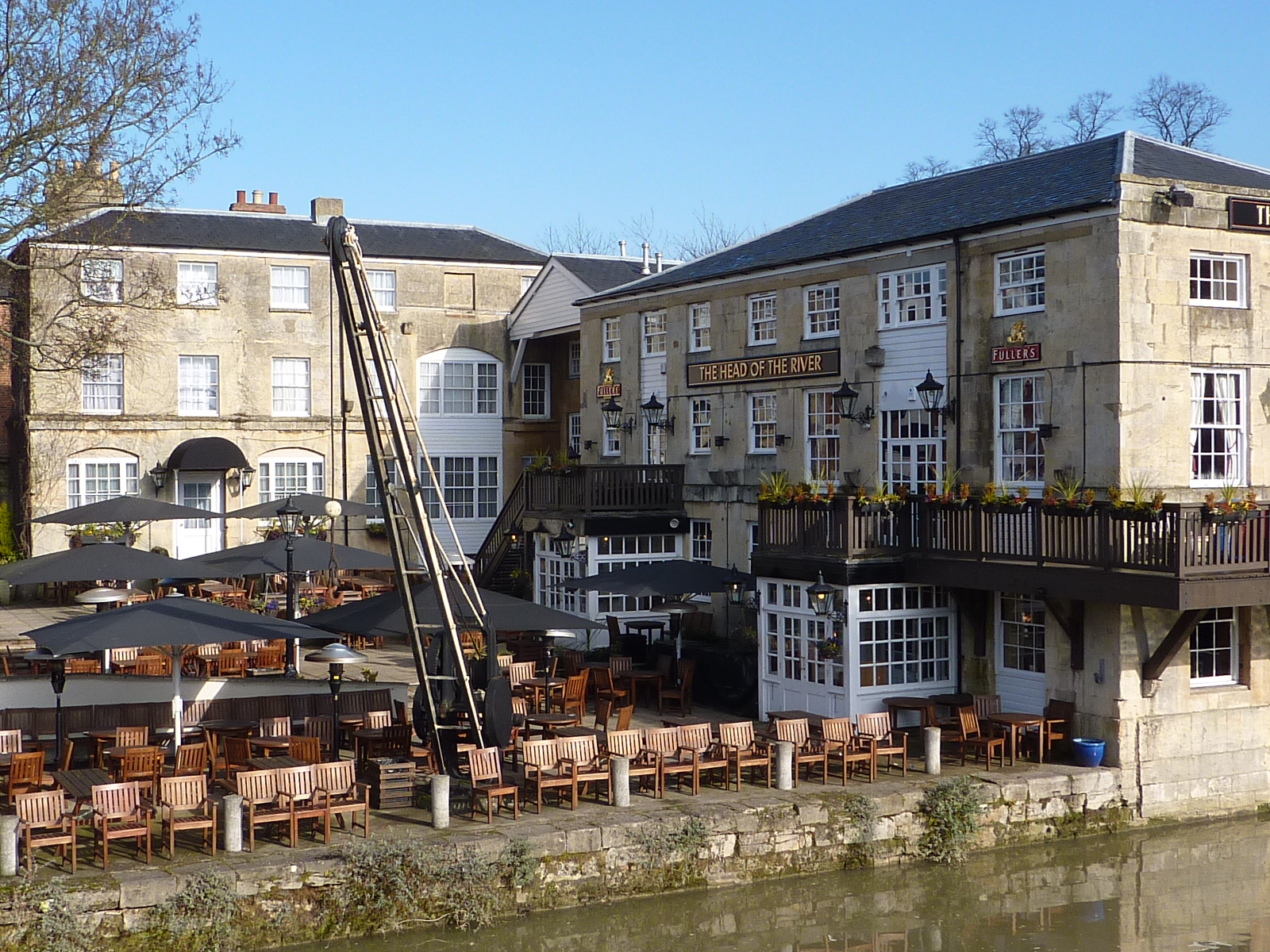
The Head of the River at Folly Bridge, which occupies what was once Isaac King's boatyard. The 'St Aldate's Yard' as it was called comprised a wharf house and warehouse, another warehouse, a dwelling house, two stables, several covered sheds, and the adjacent wharf. The buildings can be seen near the top of this plan of 1844. The wharf house and main warehouse, shown in this photo, were built in 1827, when Folly Bridge was rebuilt, but the wharf is much older, and dates back to at least 1638. In 1858 the site was taken over by Salter's Steamers. In 1977 the warehouse was converted into a pub and the wharf became the pub's courtyard garden; a winch, which was used to lift materials on and off boats, is still in place there. The name 'The Head of the River' refers to the rowing boat which is in front at the end of each day of the four-day university 'Summer Eights' bumping races - the finishing line is just to the east of the pub. The name was decided by a competition in the Oxford Mail; out of 2,700 entries, Mr Lewis Fisher's suggestion was chosen, and his prize was a gallon of whisky.
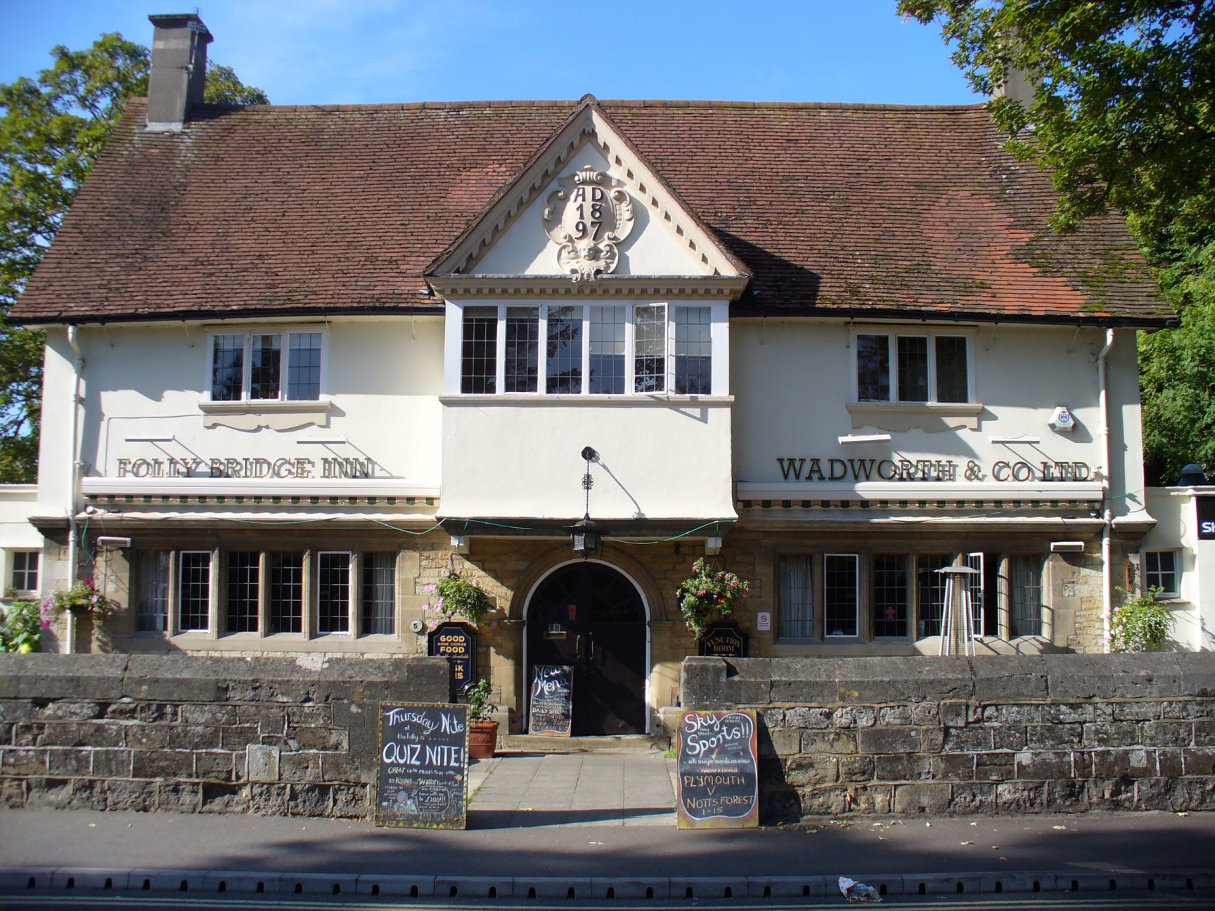
The White House is at 38 Abingdon Road, on the corner with Whitehouse Road. It was originally called the White House Inn, became the Folly Bridge Inn in 1980, and was named the White House again in 2013. It is owned by Brasenose College and was built in 1897 by the architect Henry Thomas Hare, whose grandest Oxford building, our town hall, opened in the same year. Hare also designed 63 Abingdon Road in 1902 for Brasenose, a building which shares the Arts and Crafts charm of the White House. The pub is listed Grade II. This sketch of the pub by a local resident Dorothy Brooks shows what the building looked like before the removal of some of the chimneys and the addition of the toilet block on the southern side. This block, and another on the northern side, were added in the late 1920s or early '30s, reflecting a national trend in pubs at the time, which were trying to improve their image by attracting women customers.
An earlier pub called the Old White House stood on a site just to the west of the current pub, on Whitehouse Road. It can be seen on this extract from the Ordnance Survey map of 1878. Henry Hare was asked by Brasenose College to prepare plans to update this original building, but it seems that they opted instead to commission him to build the new pub that we have today. The Old White House was finally demolished in 1919 to make way for new stands for Oxford City's Whitehouse Football Ground.
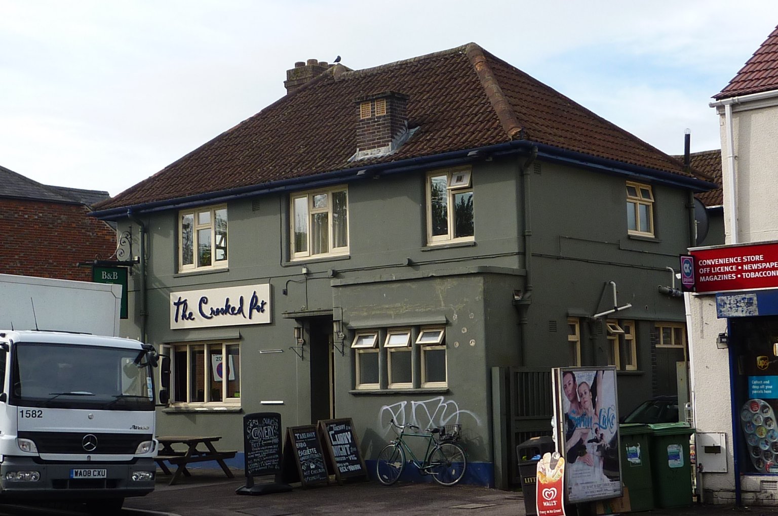
The Berkshire House at 200 Abingdon Road, on the corner of Vicarage Road, is so-named because until 1889 Grandpont, New Hinksey and Cold Harbour were in the county of Berkshire. The pub was first recorded in the mid 1860s but the present building was built in 1938 to designs by the by the well-known Oxford architect Gilbert T Gardner. The owners were Morrell's Lion Brewery.
In March 1914 Thomas Heath, who was landlord of the Berkshire House, was killed at the level crossing at Hinksey Halt. He was 59. His widow Lucy was paid £5 by the Great Western Railway company as 'a gratuity towards funeral expenses'.
The pub has also been known as the Old Berkshire House, the Crooked Pot (until late 2014), Hubble and Home, and Home.
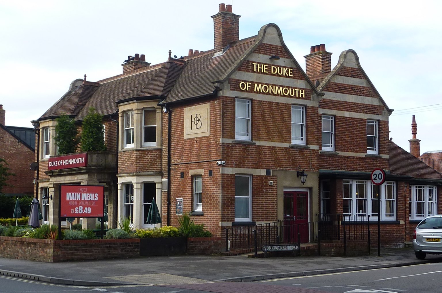
The Duke of Monmouth at 260 Abingdon Road, on the corner of Sunningwell Road, was built as a house in 1896 and converted into a pub (with the addition of a large extension at the back) in 1930 for Hall's Brewery. The letters HOB, 'Hall's Oxford Brewery', can be seen high up on the front façade. Hall's was founded in St Thomas's (in west Oxford) by Willam Hall in the late 18th century, and the brewery owned many pubs in the city. By the 1870s there were around nine independent breweries in Oxford, and in the later 19th century Hall's began to take these over, as well as others in Wallingford and Bicester. Eventually Hall's took over all the other Oxford breweries except Morrell's (which was on St Thomas's High Street). Hall's and Morrell's therefore went into the 20th century as the two main commercial rivals in Oxford's brewing industry. Hall's itself was later taken over by Ind Coope, but Morrell's remained independent until its closure in 1998.
For more information on Oxford's brewing industry see:
- The Victoria County History of Oxfordshire, vol 2, pp.225-277 (1907).
- James Bond, The Oxfordshire Brewer (Oxfordshire Museum Services, 1985).
- Mike Brown, Oxon Brews: The Story of Commercial Brewing in Oxfordshire (Brewery History Society, 2004).
- Liz Woolley, 'Industrial Architecture in Oxford, 1870 to 1914', Oxoniensia, vol 75 (Oxfordshire Architectural & Historical Society, 2010).
At least ten pubs have been lost: The Boathouse Tavern (or Old House Tavern) was at the eastern end of Folly Island, beneath Folly Bridge, from at least the 1830s until the 1890s. The Falcon Boat Club (now based at Donnington Bridge) had its headquarters here. Salter's Steamers bought the building and demolished it in 1900 to make way for their new offices and clubroom. The Marlborough House was built in 1888 at 60 Marlborough Road, on the corner of Western Road, by John Taylor, the landlord of the Dolphin & Anchor on St Aldates. It closed in 2008 and has now been converted into flats and a café for the Ethos Hotel opposite. The Grandpont Arms was at 1 & 3 Edith Road; it was built in around 1894. The building has now been converted into two houses, one of which retains the Hall's Brewery sign by the front door.
Until the early 2000s there were still two pubs on Lake Street: the Crown at no. 23, which was first recorded in the 1860s, and the Seven Stars at no. 30, which was first recorded in the early 1870s. Mrs Butler was a well-loved landlady at the Crown in the 1950s and the pub was known locally as 'Butler's'. At 51 Vicarage Road was the Edward VII. A beerhouse was first recorded here in the 1870s, though it must have originally been called something else - possibly the Hinksey House - because Edward VII didn't come to the throne until 1901. The current pub building was built in 1937. The pub had several darts, Aunt Sally and bar billiards teams; it closed in 1991 and is now a private house but it still has its Hall's sign. At 216 Abingdon Road, between Vicarage Road and Norrey's Avenue, was the New Hinksey Inn. It was first recorded in the 1860s, when it was called the White Horse Inn and the address was 2 South Parade, New Hinksey, which was a row of eight cottages on the Abingdon Road. The pub seems to have changed its name in around 1874. It closed in 1929 and the licence went to the newly-opened Duke of Monmouth (see above). The building was converted into a shop; most recently it was a hairdressers. In 1997 the property was converted into two dwellings.
At 279 Abingdon Road, on the corner of Weirs Lane, was the Fox and Hounds which was built in 1926 by Oxford architect JR Wilkins. It replaced an earlier cottage inn of the same name situated immediately to the south, known for horse-dealing. The pub closed in 2007 and the building became derelict; it suffered a serious fire and has now been demolished to make way for a Tesco store. Just to the south of Weirs Mill, off Weirs Lane, was the University House pub, formerly known as the Weirs. On 17 May 1732 Thomas Hearne recorded in his diary: 'On May 13th a party of 15 ringers came to Oxford from London on foot. They rang peals at Magdalen and Christ Church. On the 17th they began to ring a peal of 5,040 changes at New College but after 3/4 hour one of the ropes broke and so they were stopped. Afterwards they dined at the Weirs beyond Friar Bacon's Study and afterwards rang 700 changes at Iffley.' The Weirs or University House closed in around 1920 but the building still exists as a private house. In the 1970s the Thames Conservancy found numerous Victorian bottles and glazed beer mugs when dredging the adjacent Weirs Pool.
At the far southern end of Abingdon Road, on the western side, was the Farriers Arms, a white-washed cottage originally built in 1776 as a private house. (It was sometimes called the Further White House to distinguish it from the White House pub on Whitehouse Road.) By 1779 the building was being used as an isolation hospital for smallpox victims but in 1872 it became a pub. (The City Isolation Hospital was built opposite in 1883.) From the 1930s until its closure in 1963 the pub was run by three generations of the Ayres family; beer was apparently served directly from the cellar over a stile door throughout that period. Len Viner, who lived in the nearby paper house, was well-known for drinking at the Farriers Arms and for always turning up five minutes before opening time, at 5.55pm. His gravestone in the churchyard of St Laurence's in South Hinksey features a clock face showing this time. Len's nephew Don Bennett recalls his uncle and the Farriers Arms here. The pub was just outside the city boundary, and hence able to stay open until 11pm, half an hour later than pubs in Oxford. Barry Strange remembers that as a result it often attracted a good number of customers at about 10pm. After the pub closed in 1963 the building served briefly as the Oxfordshire County Surveyor's Office during the building of Oxford's by-pass, before being demolished to make way for a spur road which joins the Abingdon Road with that by-pass.
Do you know of any other South Oxford pubs which have been lost? Do you have any more information about those mentioned above? If so, please
- There are lots of good photos of people enjoying time at various Grandpont, New Hinksey and Cold Harbour pubs in Carole Newbigging, The Changing Faces of South Oxford and South Hinksey, Books 1, 2 and 3 (Robert Boyd Publications, 1998-2003).
- For more information on the history of Oxford's pubs see Paul Marriott, Oxford Pubs Past & Present (self-published, 1978).
- For a list of Oxford's lost pubs see the Lost Pubs Project website.
- For information on pub-going (and other recreational activities) in Victorian Oxford see Malcolm Graham The Suburbs of Victorian Oxford: Growth in a Pre-Industrial City 'Recreation' pp.424-461 (DPhil dissertation, University of Leicester, 1985).
Looking along Lake Street towards the Abingdon Road during flooding in 1890. The Crown is on the right at no. 23. At this time there was a gap between the pub and its neighbour, but now this gap has been built across and the house at no. 23 is wider than the pub was. (Click on image to close)
![[Lake St flooded, 1890, Taunt]](/images/photos/Local_history_section/Pubs/Lake_St_flooded_1890_Taunt.jpg "Lake St flooded, 1890, Taunt")
Plan of Folly Bridge and its surroundings drawn up in July 1844, shortly after the opening of the nearby Great Western Railway station, when nearby wharves were for sale by auction. St Aldates Yard (Lot 1) was later owned by Salter's; it is now the site of the Head of the River pub. The key to the buildings is lower down. Image © the Bodleian Library, ref: Bodl GA fol B 71, 132. (Click image to close)
![[Auction of wharfs, Folly Bridge, 1844, Bodl GA fol B 71, 132, map]](/images/photos/Local_history_section/Folly_Bridge/Auction_of_wharfs_Folly_Bridge_1844_Bodl_GA_fol_B_71_132_map.JPG "Auction of wharfs, Folly Bridge, 1844, Bodl GA fol B 71, 132, map")
Plans drawn by architect HT Hare for additions to the Old White House pub, date unknown. Images courtesy of Brasenose College. (Click on either image to close)


The last part of Old White House being pulled down to build new stands on the Whitehouse Football Ground, Oxford Journal Illustrated, 12 November 1919. (Click on image to close)

The Boat House Tavern, south east of Folly Bridge, c. 1865. Image from the Henry Minn collection, Bodleian Library, MS Top Oxon d.493, p.32. (Click on image to close)

Weirs paper mill on the Weirs mill stream, close to where Donnington Bridge now crosses the river. Copyright John Burbank, and reproduced with his permission. There is another painting of the mill here. (Click on image to close)
![[Weirs Paper Mill, painting]](/images/photos/Local_history_section/Paper_houses/Towles_paper_mill_Cold_Harbour_Weirs_Mill_Stream.JPG "Weirs Paper Mill, painting")
The Weirs pub, close to where Donnington Bridge now crosses the river, drawn by Dr William Crotch in 1801. Left-hand image from the Henry Minn collection, Bodleian Library, MS Top Oxon d.493, p.57. Right-hand image courtesy of Olympia Auctions, October 2024. (Click on either image to close)
![[Weirs pub, 1801]](/images/photos/Local_history_section/Pubs/Weirs_pub_Cold_Harbour_1801_Minn_MS_Top_Oxon_d.493_Folly_Bridge__Abingdon_Rd_p57.jpg "Weirs pub Cold Harbour 1801 Minn MS Top Oxon d.493 Folly Bridge Abingdon Rd p57")
![[Weirs pub, 1801]](/images/Weirs_near_Oxford_28_Apr_1801_William_Crotch_Olympia_Auctions_Oct_2024.jpg "Weirs pub Cold Harbour 1801 Olympia Auctions")
A sketch of the White House pub (seen from the south-west) by Dorothy Brooks, showing what the building looked like before the addition of the toilet block on the southern side, and the removal of some of the chimneys. Dorothy lived at 7 Whitehouse Road for over 80 years, until her death in 1977. She has labelled the sketch 'The Old White House' but in fact it is the 'new' White House, built in 1897 (and still there now). The pub continued to be labelled on maps as the 'Old White House' until at least the late 1930s. Image courtesy of Clive Organ. (Click on image to close)
 the Grandpont Arms