
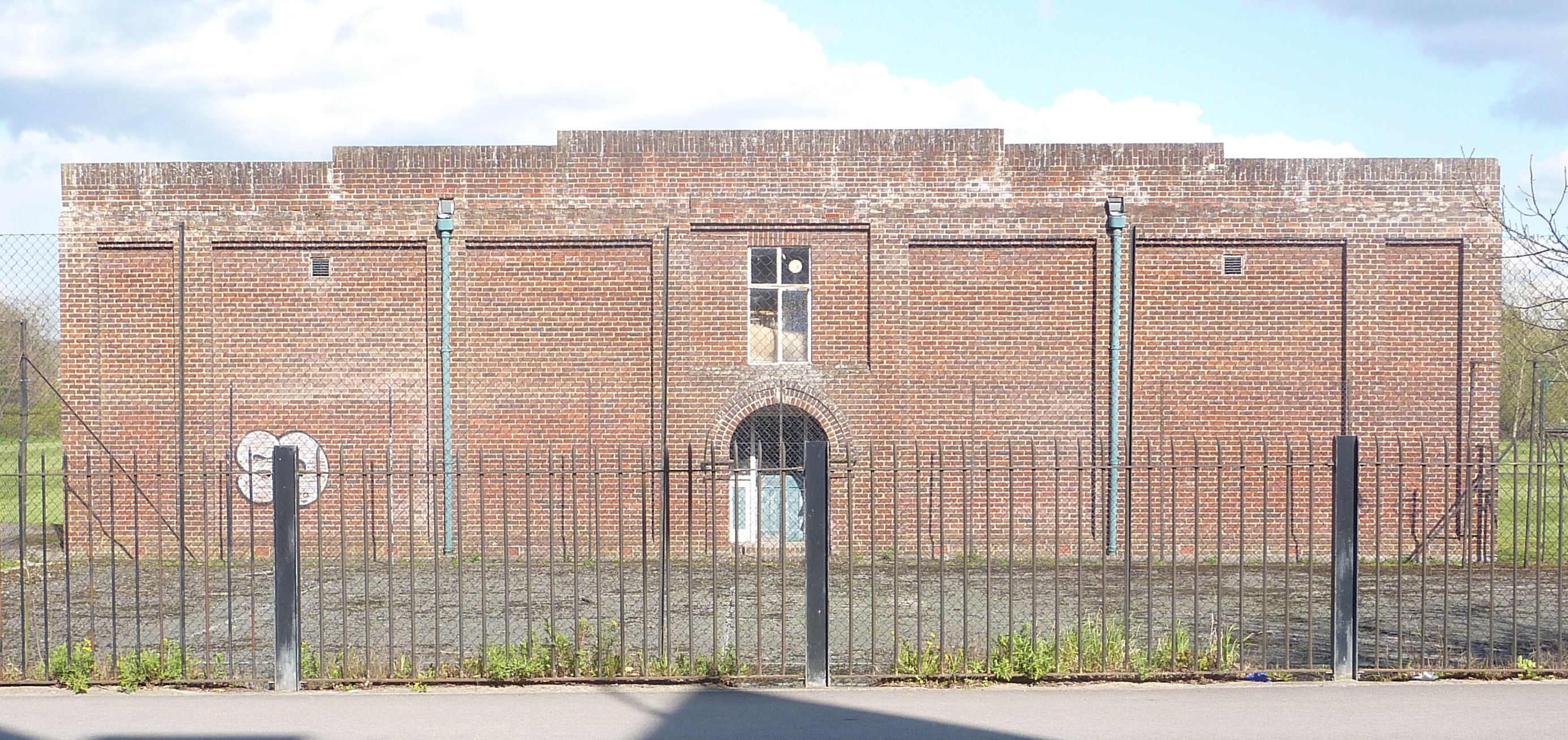
The University College cricket pavilion (south-eastern façade) in 2023; image courtesy of David Clark.
This building is to the east of the Abingdon Road, down a short path opposite 232 Abingdon Road. It was built in 1913-14 and opened on 23 May 1914. The architect was Clough Williams-Ellis, who is best known for Portmeirion, his architectural fantasy village on the North Wales coast. The pavilion has been described by architectural historian David Clark as “one of the architect's most charming (pre-Portmeirion) buldings”.
In the nineteenth century, University College cricketers practiced and played on Cowley Marsh, where many of the colleges had their cricket fields and pavilions. (Magdalen Cricket Ground (off Magdalen Road, and after which Cricket Road is named) was where the University Cricket Club played until it relocated to the University Parks.) After the turn of the century there had been some discussion in college about a new cricket pitch, but no action was taken, probably due to lack of money. But in 1912-13 undergraduates gathered donations from past and senior members to fund a new cricket pavilion and pitch, to be built on a field on the southern side of Eastwyke Farm, off the Abingdon Road. This was land which University College owned but leased to the butcher Leonard Alden; in 1913 the college assured the local office of Agricultural Returns that sheep would not be grazed on the cricket ground.
Clough Williams-Ellis was almost certainly given the job of designing the new building via the college's Dean, Arthur Spencer Loat Farquharson, who was also honorary treasurer of the University College Cricket Club. Farquharson - a popular Fellow nicknamed ‘the Farq’ or ‘Farquhie’ - was a keen supporter of sports, and in particular of cricket. He had family living at Cumnor, just to the west of Oxford, where Williams-Ellis was carrying out a number of commissions. It is likely that Farquharson saw Williams-Ellis's work there and thought that his style would suit the proposed college pavilion and groundsman's cottage.
The builder was not a local firm, but Charles Elcock of Hartfield in Sussex, probably someone who Williams-Ellis had worked with before. The design of the building means that the cricketers who used it, and the groundsman and his family who lived in it, must have frequently come into contact. On the ground floor (raised up four feet so as to be above flood level), the large room at the front (opening out onto the colonnaded verandah) was the club room. Behind were dressing rooms, baths, showers and WCs for the cricketers, as well as the family's living room and the 'servery'. A central staircase led to the first floor where there were two bedrooms and two large storerooms, presumably for sports equipment. The clock- and bell tower at the front of the building has a glazed double door at first floor level, looking out over the cricket pitch and potentially leading on to the roof of the verandah. Decorative scrolls either side of this structure, shown on William-Ellis's original plans, were omitted, probably for reasons of cost.
In 1921 the living accommodation was occupied by the long-serving University College groundsman George King and his wife Eliza. They had previously lived in east Oxford (closer to the Cowley Marsh cricket fields mentioned above) and as a younger man George had worked as a 'professional cricketer' i.e. someone who taught undergraduates how to play.
- Find out more about this and other buildings in Oxfordshire by Clough Williams-Ellis in David Clark, “‘Family Jobbery’: How Clough Williams-Ellis Obtained His Earliest Commissions in the Oxford Area”, in Oxoniensia, vol 89 (2024), Oxfordshire Architectural and Historical Society.
Clough Williams-Ellis's plans for the University College cricket pavilion and groundsman’s cottage, August 1913. Courtesy of the Oxford City Council Archives. (Click on image to close)

The squash courts on the eastern side of the Abingdon Road, opposite nos. 90-96, were built by Brasenose on the college's sports ground in 1937. The playing area for the game of squash was not standardised until 1923, and the Brasenose courts are a rare surviving example of a purpose-built double court from this early period in the game's history.
Click here for an architectural and historical report on the building by the Oxfordshire Buildings Record.
The courts were added to the Oxford Heritage Asset Register in July 2018. The register recognises buildings which make a special contribution to the character of Oxford and its neighbourhoods through their locally significant historic, architectural, archaeological or artistic interest. It is sometimes called 'the local list' and gives buildings a degree of extra protection in planning terms should proposals be put forward to radically alter or demolish them.

Hay harvest on Dean’s Ham meadow, behind Marlborough Road, June 1900. The boy sitting holding a cricket bat may have been usefully employed as a rat basher. Image © Oxfordshire County Council, Oxfordshire History Centre, ref: D263257a.
Dean's Ham is the area of open meadowland to the west of the houses at the southern end of Marlborough Road; their gardens back on to it. The name 'Dean's Ham' seems to derive from the Old English 'denu', meaning valley, and 'ham' meaning field or meadow i.e. a field or meadow at the bottom of a valley or, in this case, on the Thames flood plain. In the late 19th century and early 20th century the meadow was also sometimes know as 'Archer Cowley's field' because the southern end of Marlborough Road was originally called Archer Street.
John Slatter was the owner of the meadow in 1844 and Moses Brooks was the yearly tenant. John Slatter was the nephew of Henry Slatter, founder of Slatter & Rose’s bookshop on the High Street. John Slatter died in 1890, and via a complicated chain of bequests, the land eventually came into the hands of his daughters Bessie and Sarah. In the early 20th century Thomas Hathaway, a horse-dealer, leased the meadow from the Slatter family, and in the First World War hay was cut here and sent to the Western Front for the army's horses.

Looking north across Dean’s Ham during the great floods of 1947. The back gardens of the houses at the southern end of Marlborough Road are on the right. In the background, to the left, are the chimneys of the St Ebbe's gas works. (Image belonging to Sidney's daughter Brenda Horwood, courtesy of Gill Garrett / Debby Forbes.)
In 1926 the Slatters sold the meadow to Oxford City Council for £1,000; by the early 1930s it had become a council recreation ground which originally included the area to the south now occupied by allotments. There was a wooden footbridge across Eastwyke Ditch linking the two parts. It was a wonderful play area for local children, though only those aged under 14 were allowed on to it. In the inter-war period circuses and carnivals were held on Dean's Ham; in the 1950s an oval cycle track was laid out on it and it was home to the South Oxford Football Club.
- See photographs of football and cycling on Dean's Ham in Carole Newbigging, The Changing Faces of South Oxford and South Hinksey, Book 1, pp.40-42 (Robert Boyd Publications, 1998).
A steam hay presser in Archer Cowley's field (Dean's Ham) supplying 150 to 200 tons of hay per day for the army. Oxford Journal Illustrated, 1 September 1915. (Click image to close)

Grandpont from the air, 1918. St Matthew's church and the Whitehouse football ground can be seen at the centre right of the picture; Whitehouse Lane (bright white in colour) runs westwards from the south-west corner of the football ground, across fields and out to Grandpont Farm. It then turns south-west to cross the railway line on a level crossing. Image © Oxfordshire History Centre. (Click image to close)

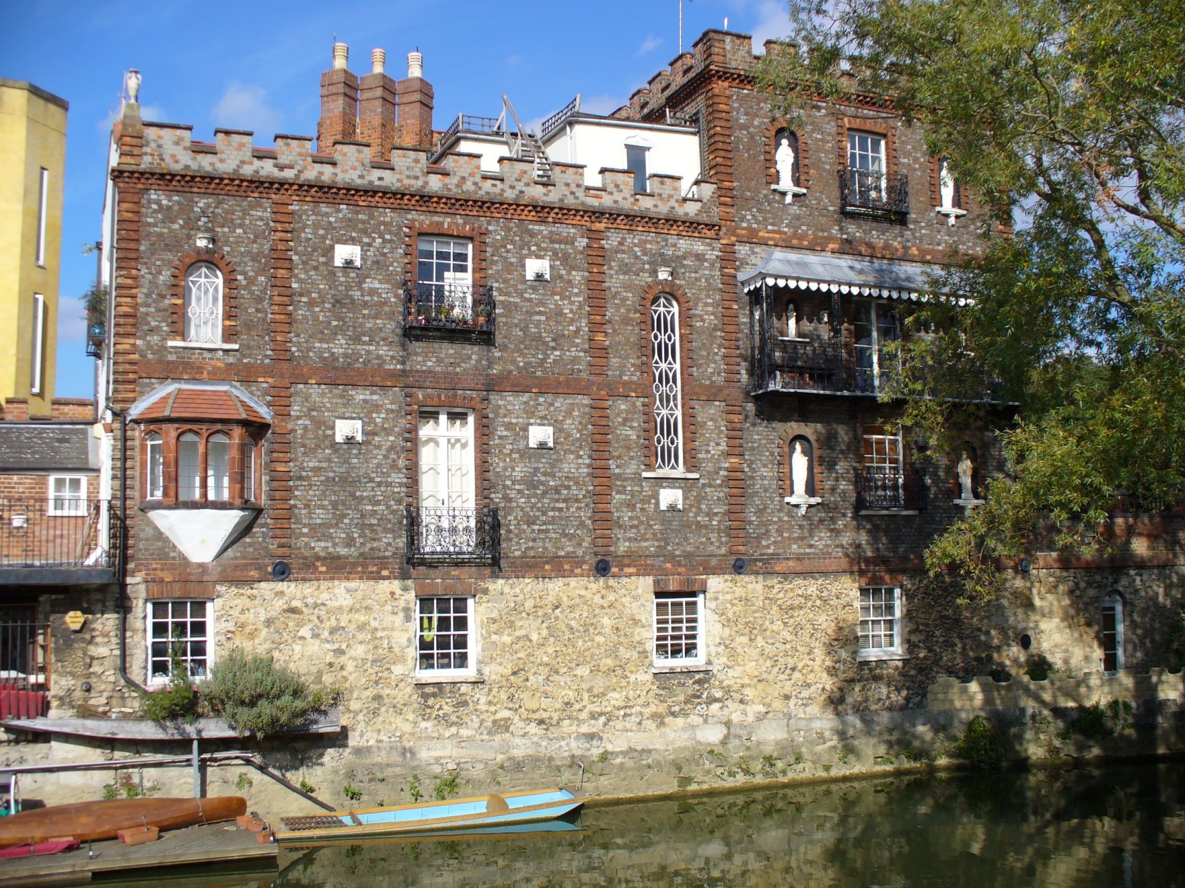
Originally known as North Hinksey House, this building was erected on Folly Bridge Island in 1849 for Joseph Caudwell, an eccentric Oxford accountant who perhaps planned it as a folly to match the existing name of the bridge. 'Caudwell’s Castle' soon attracted unwanted attention from high-spirited undergraduates, one of whom was shot and seriously hurt by Caudwell in 1851 while trying to drag one of the cannons that sat on the forecourt into the river. At his subsequent trial Caudwell was found not guilty after his counsel made much of the malicious intent of the students who '...after luxuriating at a cricket club supper at the Maidenhead, smoking cigars and drinking beer, sallied forth, and in order to fill up or rather to kill time, proceeded to this man’s house for wanton mischief, and to despoil his premises, for the sake of gratifying a morbid and wicked disposition'.
The building features an interesting variety of windows and a number of plaster statues including, on the roof of the roadside facade, Atlas, who has unfortunately lost his globe. On the ground floor below him you can see what was originally the front door, now bricked up, with the forecourt in front of it (but no cannons).
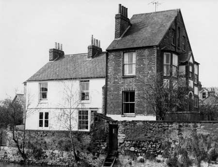
4 Folly Bridge Island prior to crenulation in 1974.
Just to the west of Caudwell's Castle is 4 Folly Bridge Island which was built in 1875 and designed by the Oxford architect George Shirley. As this old photograph shows, it originally had a steeply-pitched roof, but the upper storey was rebuilt and crenelated in 1974. If you stand on the towpath at the end of Codben Crescent, and look at the back of the house, you can see the old roof-line and the outline of where the chimneys used to be.
To the south of Caudwell's Castle, across the river on a small triangle of land beside one arch of Folly Bridge, was a public lavatory. It can be seen marked 'Lav' at the centre of this extract from the 1939 Ordnance Survey map ['FB' means 'footbridge']. This small brick building still exists, though it is more-or-less invisible as it is totally overgrown with ivy and has two large willow trees immediately beside it. However, the gate to it in the iron railings, just to the west of the pedestrian crossing over the Abingdon Road, can still be seen.
- For a guided walk around this area see Malcolm Graham, On Foot from the High to Trill Mill (Oxford Preservation Trust, 2020), pp.89-96.
Oxford's gasworks were in St Ebbe's - not strictly in South Oxford, but the site eventually stretched over both north and south banks of the river just north-west of Grandpont, and for local residents the noise and smell produced by the works were very much part of their everyday lives. Some worked there and others regularly passed the site on their way to and from the city centre. This photograph shows the eastern side of the gasworks site in 1945, from the towpath near the end of Marlborough Road.
![[Gasworks 1945]](/images/photos/Local_history_section/Gasworks/Gasworks_1945.jpg "Gasworks 1945")
This photograph was taken in 1945, looking west along the towpath from a spot just to the east of the northern end of Marlborough Road. The gasworks pipe bridge (now a footbridge) is near the centre; the large shed-like building behind it and to the right is the retort house. Two gas holders (whose tops look like crowns) can be seen in the distance. Image © Oxfordshire County Council, Oxfordshire History Centre, ref: D252205a.
The gasworks were Oxford's first large-scale markedly 'industrial' building complex. They were established by Act of Parliament on 23 May 1818 under the name of 'The Oxford Gas, Light and Coke Company', though it was recorded in all early advertisements as 'The Oxford University and City Gas Light and Coke Company'. The works were initially on a two-acre site on the north bank of the Thames just to the south-west of the city centre. A print entitled View of Oxford, from the meadows near the gas works shows the works in 1835, viewed from Osney Mead.
The raw material - coal - was delivered to the works by boat, and residual by-products (coke, tar, sulphur and ammonia) despatched via the same route. St Ebbe's was low-lying, so that the natural increase in pressure, as it rose in the mains, could be utilised. It was also far enough from the city that the noise and fumes it produced did not affect the residents of the central parishes too greatly. Soon after the arrival of the gasworks, hundreds of terraced houses were built in a grid of streets around the works site, north of the river, creating the densely-packed suburb of St Ebbe's. Towards Folly Bridge, a series of wharves, timber yards, a saw mill and (until 1856) the city waterworks, contributed to the area’s industrial character.
![[Gasworks plan]](/images/photos/Local_history_section/Gasworks/Gasworks_plan.jpg "Gasworks plan")
The original gasworks were founded in 1818 on the northern bank of the Thames (shaded red on the plan above). The gasworks eventually occupied sites on both sides of the river, totalling 19 acres. The South Works were immediately to the west of Grandpont; the northern end of Marlborough Road, and the pipe bridge near it, can be seen on the far right of the plan. On the left, the framed plan of the works as they were in 1869 shows the close proximity of terraced housing and Holy Trinity Church. Image © The National Grid (Oxford and District Gas Company), copy in the Oxfordshire History Centre, ref: OxS, OXFO 665.7.
Gas was Britain's first true utility industry, with some large, vertically-integrated companies which paved the way for future public utilities. By the 1830s most towns had gas lighting; it was first introduced to Oxford in 1819 and gas street lamps were lit by hand at sunset, and switched off at sunrise, except during the three summer months. In the later 19th century the scale of gas manufacture grew enormously as rapid increases in population, rises in real wages, and the advent of the mass media fuelled a growing demand for manufactured goods and for clean water and power. Gas was used more and more for cooking, heating, and for powering industrial engines. The amount of gas sold nationally increased threefold between 1882 and 1912 and the number of gas companies almost doubled to 826. Gasworks developed and grew correspondingly.
The local newspaper Jackson's Oxford Journal reported frequent improvements and extensions to the Oxford works, particularly from 1870 onwards. In 1871 a new retort house [in which gas was produced by heating coal in vessels called retorts; marked '1' on the North Works site on the plan above] was built on a newly-acquired three-quarter-acre plot adjacent to the existing premises. It necessitated the demolition of ten houses but allowed an increase in the number of retorts from 181 to 252, so that the works could cope with rapidly increasing demand.
By 1882 there were 3,600 gas consumers in Oxford [the city's population was around 41,000]. The gasworks acquired land south of the Thames (just to the west of the newly-developing suburb of Grandpont) partly from University College. Here the company built new plant and gasholders, though opposition from both city and university prevented the actual manufacture of gas there. In 1886/7 a specially-built spur of the Great Western railway was constructed to serve the works. Jackson's Oxford Journal noted that 'The inconvenience and expense of carting coal through the streets from the Railway Station to the Gas Works has long been felt, and the present undertaking will prove a saving to the ratepayers of the City, and the roads will be relieved of their heavy traffic.'
The spur crossed the Thames just to the west of the gasworks on a new bridge - Isis Bridge - which was built immediately beside the existing Great Western mainline railway bridge. Both these bridges still carry railways today.
![[Gasworks bridge under construction Taunt 1886 HT140]](/images/photos/Local_history_section/Gasworks/Gasworks_bridge_under_construction_Taunt_1886_HT140.jpg "Gasworks bridge under construction Taunt 1886 HT140")
A section of the new gasworks railway bridge being floated along the Thames on barges during the bridge's construction in 1886. Health and safety were obviously not major concerns. Photograph by Henry Taunt, © Oxfordshire County Council, Oxfordshire History Centre, ref: HT140.
The line then crossed the Thames again, further south, on another new bridge (which also still exists) built privately by the gas company. This was designed by engineer Charles Hawksley and cost almost £6,000. The central cast iron piers were sunk twenty feet into the river bed and the floor of the bridge was supported by cross girders three feet deep through which cast iron gas pipes passed. These can still be seen under the bridge. (This bridge and the railway spur can be seen near the centre of the plan above: the single-track spur leaves the main line between the gasholders marked '36' and '35' and then curves south of gasholder '35'.)
![[Gasworks bridge loco holder c. 1920 D254356a]](/images/photos/Local_history_section/Gasworks/Gasworks_bridge_loco__holder_c._1920_D254356a.JPG "Gasworks bridge loco holder c. 1920 D254356a")
The completed bridge with a coal-carrying locomotive crossing it and one of the six gas holders behind, 1925. Image © Oxfordshire County Council, Oxfordshire History Centre, ref: D254356a.
The bridge was a multifunctional structure: one half of its platform supported a single track of rails, the other was used as a cart road on which horses pulled wagons laden with coal, because GWR steam engines were not allowed on to the private gasworks railway. This continued for twenty years until 1907 when the gas company purchased its first steam locomotive. A footway with granite kerbs allowed workers to cross between the sites on the north and south banks of the river. On the northern side the rails were carried on an elevated wooden gantry eleven feet above the ground as far as the retort house.

The gasworks pipe bridge, erected in 1927 by Head Wrightson & Co Ltd, engineers of Thornaby-on-Tees.
Instead, in 1927, a new footbridge was built over the river, slightly further west. It allowed workers to cross between the north and south sites of the gasworks, and it also carried two large gas pipes (hence it is often known as the gasworks pipe bridge).
This coloured drawing of the footbridge was done by W Eames Caton, General Manager and Engineer at the gasworks, in 1922, showing that the bridge had been planned for some time.
It is now a public footbridge (and part of Sustrans cycle route 5) linking Grandpont with St Ebbe's and the city centre. In March 2021 the bridge was unexpectedly closed, the City Council having received a report warning that it was unsafe. It was carefully restored and re-opened in January 2025.
The pipe bridge and the two railway bridges (the southern of which is also now a footbridge) are the last physical vestiges of the St Ebbe's gasworks, which closed in 1960. Thereafter Oxford consumers got their gas from Southampton and Reading until North Sea gas became available in 1971. Two gas holders remained in use at St Ebbe's until 1968 but these and all the other structures relating to the gasworks, apart from the three bridges, were eventually demolished. (The same thing was happening to 19th-century gasworks across the country.) Preachers Lane housing estate now occupies part of the northern site, and Gas Street, which was the original entrance to the works, no longer exists. The suburb of St Ebbe's itself, which grew up around the gasworks on the northern bank of the river in the 1820s, was also cleared, and many of its residents went to live in newly-built Blackbird Leys. The Westgate shopping centre now occupies much of the area, which was once criss-crossed with streets lined with two-up two-down terraced houses.
The rest of the gasworks site is now a nature reserve with a pleasant riverside walk running through it. But when the gasworks were functioning, between 1818 and 1960, this area was very different. The poet WH Auden (1907-1973), an undergraduate at Christ Church in the mid 1920s, would bring visitors here to show them what he considered to be the embodiment of 'The Waste Land' described in TS Eliot's poem of the same name, of which he was a great admirer.
The Gas Light & Coke Company's showrooms and offices were opened at 96 St Aldates in 1921, and moved to larger premises at 119 St Aldates in 1938. The balcony of the building includes this rather charming depiction of 'Mr Therm', an animated character who featured in the company's advertising in the 1930s.
Amazingly, there were still over 1,800 gas street lamps in Oxford in 1963, and the last was not switched off until 1979.
- For a comprehensive history of the Oxford gasworks see Colin Judge, The Railway, Locomotives & Company History 1818-1960 of the Oxford Gas Light & Coke Company (Industrial Railway Society, 2023).
- For a guided walk around the St Ebbe's gasworks area see Liz Woolley, Oxford's Working Past (Huxley Scientific Press, 2012).
- For more old photographs and information on the gasworks site see Carole Newbigging, The Changing Faces of St Ebbe's and St Thomas, Book 1, p.27 (Robert Boyd Publications, 1997) and Carole Newbigging, The Changing Faces of South Oxford and South Hinksey, Book 3, pp.88-90 (Robert Boyd Publications, 2003).
- For more information on Oxford's gas supply to the developing suburbs see Malcolm Graham The Suburbs of Victorian Oxford: Growth in a Pre-Industrial City 'Water, Gas and Electricity' pp.385-388 (DPhil dissertation, University of Leicester, 1985) and the Victoria County Historyof Oxfordshire, vol 4, pp.350-364.
- For a nice print of Oxford showing the gasworks in 1835, and more information about the development of the site, see Stephanie Jenkins's Oxford History website.
- For an explanation of how gasworks work see this Wikipedia page.
- For more information on the history of the suburb of St Ebbe's see the two history information boards at the junction of Preachers Lane and Blackfriars Road, near the pedestrian crossing over Thames Street. There are two further information boards specifically about the gasworks on the pipe bridge.
- For more information on bridges over the Thames see James Dredge, Thames Bridges from Tower to the Source (1897).
Looking north along the river towpath in 1897, towards the Great Western Railway's Isis Bridge, which carried a spur of the railway serving the gasworks. The mainline railway bridge is immediately behind it (but only its supporting piers can be seen). These two bridges, and the curving footbridge beyond, still exist. Image from James Dredge, Thames Bridges from Tower to the Source (1897). (Click image to close)
![[GWR Isis Bridge for gasworks spur Dredge 1897]](/images/photos/Local_history_section/Gasworks/GWR_Isis_Bridge_for_gasworks_spur_Dredge_1897.jpg "GWR Isis Bridge for gasworks spur Dredge 1897")
Looking east towards the gasworks railway bridge in 1897. The large supporting arches at either end were built of dark blue engineering bricks. Image from James Dredge, Thames Bridges from Tower to the Source (1897). (Click image to close)
![[Gasworks railway bridge from Dredge 1897]](/images/photos/Local_history_section/Gasworks/Gasworks_railway_bridge_from_Dredge_1897.jpg "Gasworks railway bridge from Dredge 1897")
The road bridge proposed in 1925, which would have taken Marlborough Road across the river and into St Ebbe's. It was never built. Image courtesy of the Town Hall Archives, OCA3/1/Y7/1/5 (Click image to close)
![[Proposed road bridge, 1925]](/images/photos/Local_history_section/Gasworks/Gasworks_bridge_proposed_1925_OCA3-1-Y7-1-5_smaller.jpg "Proposed road bridge 1925")
The gasworks foot bridge as proposed in 1922, which was built in 1927. Image courtesy of the Town Hall Archives, OCA3/1/Y7/1/7 (Click image to close)
![[Proposed gasworks bridge, 1922]](/images/photos/Local_history_section/Gasworks/Gasworks_pipebridge_proposed_1923_OCA3-1-Y7-1-9_3_cropped.jpg "Proposed gasworks bridge 1922")